

Relocation of the Ring Road in Mýrdalur
Information for residents at Mýrdalshreppur
The history of this project is long and has been going on for some decades, but in 2013 the master plan of the municipality Mýrdalshreppur was approved with a new Ring Road through Mýrdalur, south of Geitafjall, above Dyrhólaós and through a road tunnel in the south of Reynisfjall.
The government has provided funding for the preparation of the project from 2020-2024, but the project itself has not been financed.
Icelandic Road and Coastal Administration (Vegagerðin) is currently working on a pre-design of the alignment of a road around Mýrdalur based on drafts from 2008 and the current master plan of Mýrdalshreppur. An environmental impact assessment (EIA) will be carried out in parallel with the pre-design to ensure environmental impact to be considered during the design.
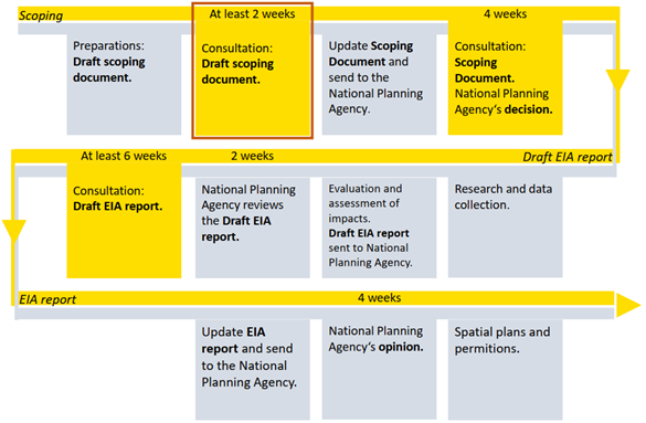
Figure 1 – Steps of the environmental impact assessment (EIA)
The scope of this project is such magnitude that it is subject to the law on environmental impact assessment (Act. no. 106/2000), Figure 1. Vegagerðin is going to undergo a comprehensive assessment as the road is planned on a sensitive area. The objectives of the assessment are defined in the law and are as follows:
•
Before
the permit for construction is available, its environmental impact has been
assessed.
•
Finding
options to minimize the negative impact on the environment.
•
Promote
stakeholder cooperation.
•
To
inform the public about the potential environmental impact of the project.
The first step in the environmental impact assessment is a draft of a scoping document, which can be found on the project's website (https://vik-hringvegur.netlify.app). The draft explains how it is planned to carry out the environmental impact assessment, the main implementation and impact aspects of the project, the research plan, and the planned data collection.
Currently, Vegagerðin is assessing comments and remarks related to the draft, to make sure all necessary aspects will be considered in the environmental impact assessment. Once the comments and remarks have been processed a proposal for an assessment plan is sent to the National Planning Agency (Skipulagsstofnun).
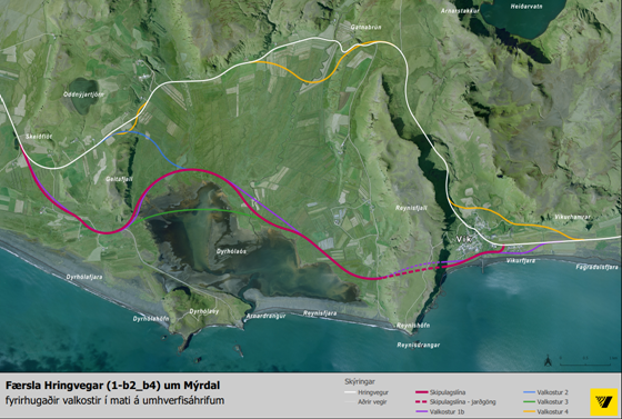
Figure 2 – Options of road alignments in the draft of assessment plan
Since the master plan of Mýrdalshreppur was approved in 2013, traffic west of Reynisfjall and on Reynishverfisvegur has almost quadrupled and traffic on Hringvegur east of Vík has more than quintupled.
When examining the options in Figure 2 it is necessary to keep the objectives of the project in mind, but they are following:
•
Agility
or pass ability in the wintertime for all traffic.
•
Improved
road and traffic safety.
o Road
alignment.
o
Visual
distances.
o
Curves
and bends.
o
Slopes.
o
Road
connections.
•
Main
road out of urban areas.
•
Shortening
of the Ring Road
The Act on Environmental Impact Assessment states that other realistic options that may be considered should be accounted for and compared regarding environmental impact. In the draft four options are shown to be compared.
Option 1 – according to the master plan / pink line on Figure 2
The road lies south of Geitafjall on the west side, along Dyrhólaós, and in tunnels in the south part of Reynisfjall. East of Reynisfjall, the route runs along the shore and joins the current road in Vík.
Option 1b – adjusted road line from the master plan / purple line on Figure 2
In parallel with the pre-design, the master plan road line has been adjusted in several places due to road technical issues. It is also considered to move the road connection to the current Ring road further east, to avoid the main road going into the township of Vík.
Option 2 – north of Geitafjall / blue line on Figure 2
The road lies to north of Geitafjall but joins the road line of option 1 above the estuary.
Option 3 – crosses Dyrhólaós / green line on Figure 2
The road is partly comparable to option 1, but instead of going north of the Dyrhólaós estuary, the estuary is partly crossed.
Option 4 – improvements to existing road / yellow line on Figure 2
The option includes improvements to the current road with the objectives of the project in mind. Improvements are made by Geitafjall and Gatnabrún, as well as the road is taken north of the town in Vík.
Zero option – white line on Figure 2
The option involves unchanged condition, where there are steep slopes, number of road connections, sharp bends and the Ring Road going through an urban area.
An environmental impact assessment will be carried out in parallel with the pre-design of the road. In the assessment, the observation or reference area will be extensive (Figure 3), in the purpose of being able to alter the design if the results of the environmental assessment or other factors warrant it.
Vegagerðin will select its main option based on the following items:
•
Requirements
for road technology and traffic safety
•
The
strategy of the municipal master plan
•
The
governments transportation strategy
•
Cost
•
Environmental
aspects
•
Community
perspectives
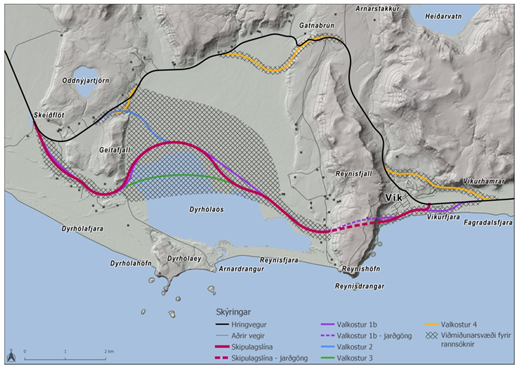
Figure 3 – The hatched area is the research reference area
In Figure 4 a rough process of the environmental impact assessment can be viewed, along with the consultation, but the evaluation process is divided into three stages:
In the first phase of the assessment, a scoping document is formulated, projects to be assessed are defined, the main impact factors of the project are explained and the environmental factors that will be emphasized are identified. The document also describes the research and data that will be obtained to assess the environmental impact of the options. First, a draft scoping document is presented by Vegagerðin, and later a proposal for a scoping document is presented by Skipulagsstofnun. At this stage, the public, stakeholders, licensors, and professional bodies will have the opportunity to make comments and remarks both to Vegagerðin and later to Skipulagsstofnun.
At the second stage of the assessment process, data is collected, the environmental impact of the project is assessed based on the scoping document and results of the evaluation reported a draft assessment report. The report includes e.g. an account of the main environmental impacts of the options, research results, compliance of options with existing plans and proposals for mitigation measures and monitoring. Based on the results of the environmental assessment and a comparison of options, the developer decides and justifies the option he considers most desirable.
The draft assessment report undertakes a formal consultation process at Skipulagsstofnun, which involves reviews from professional institution and licensors. The report will also be available on the project´s web page and at Vegagerðin webpage. During the presentation time of the report, an introductory meeting is expected to be held. Everyone is given the opportunity to make remarks on the outcome of the assessment.
In the evaluation report, which is the third step in the process, the developer responds to the comments and remarks that appear in the draft assessment report. The assessment process completes with the opinion of Skipulagsstofnun on the assessment report.
Once the opinion of Skipulagsstofnun is available, it is possible to carry on with the application process for permits.
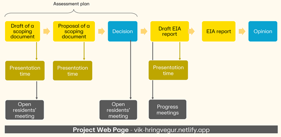
Figure 4 – Rough process of the environmental impact assessment and planned consultation
As mention earlier, Vegagerðin is going to undergo a comprehensive assessment as the road is planned on a sensitive area. The environmental assessment will describe the main effects of the project on environmental factors that are presented in Figure 5. For each environmental factor, assessment questions are formulated and account for in the research on environmental factors and in assessing the impact of the project.
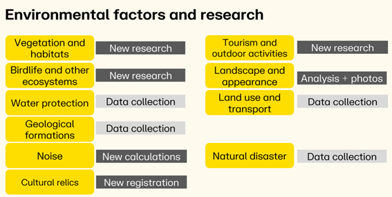
Figure 5 – The environmental factors and research to be undertaken in the environmental impact assessment